Districts and neighborhoods of Qom
With about 1.5 million residents, Qom is the seventh largest city in Iran in terms of population. This metropolis has large residential areas and important political and organizational centers, entertainment and tourism, scientific and educational, historical, medical, commercial, tourism, etc.; Also, this city has a wide network of public transportation inside and outside the city.
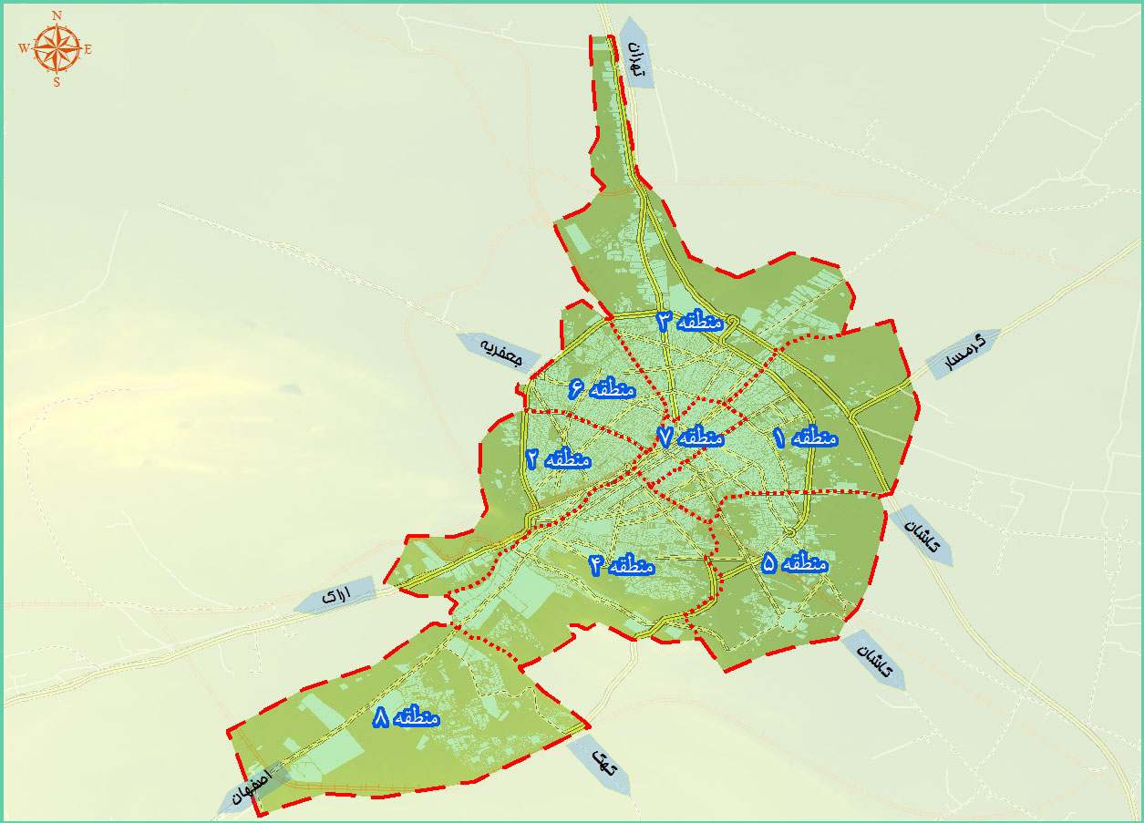
This vast metropolis has been divided into 8 regions for the optimal management of urban life of this population.
In this article, we introduce the 8 regions and neighborhoods of Qom in these regions; Continue with Royal Construction Group to fully understand the 8 districts and neighborhoods of Qom.
Tips about the 8 districts of Qom city
The largest area of Qom: Area 2
The smallest district of Qom: District 7
The most populated area of Qom: Area 7
The least populated area of Qom: Area 2
Number of neighborhoods in Qom: about 150 neighborhoods
The most worn texture: areas 1, 3, 5
Quick access to the 8 regions of Qom in the form of a complete article
Region 1
Region 2
Region 3
Region 4
Region 5
Region 6
Region 7
Region 8
Introducing the regions and neighborhoods of Qom
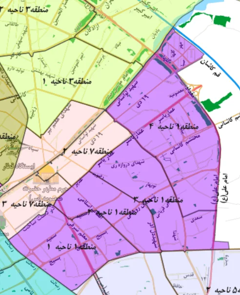
District 1 of Qom
One area of Qom is located in the east of Qom with an area of about 13 square kilometers. The neighborhoods of one region of Qom are:
Bajek 2 – Bajek 3 – Chahar Imamzadeh – Amariasar – Noqtar – Shah Seyed Ali – Municipal settlement – Sarajeh – Darwaza Ray – Nobahar – Slaughter house – Alucho – Razavieh – Pamnar – Chehl Akhtaran – Nekui – Water source – Mahdiyeh – Alwandiyeh and Gozer Sadiq – Labchal – Chahar Mardan – Sarhauz – Sidan – Sarbakhsh – Kashan Gate – Darbehesht – Sarbakhsh – Kashan Gate – Darbehesht – Passing the Castle – Moat – Sengband – Hall Bath – Conservatory – Golzar – Brason – Shah Ahmad Qasim – Castle Gate – Noble Garden – Martyr Rajaei – Uncle Hossein’s Castle
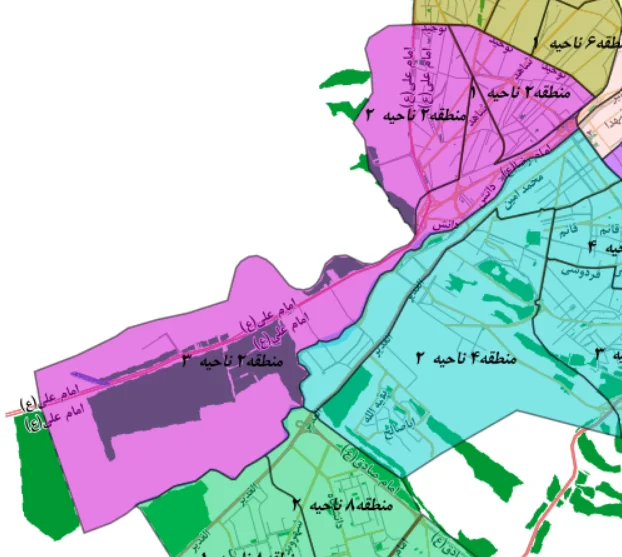
District 2 of Qom
District Two of Qom Municipality is one of the districts of Qom city, which extends from the city center to its west. The neighborhoods of District 2 of Qom are:
Forty trees – Bagh Sharifi – Mohammad Abad – Sheikh Abad – Sadeghieh – Amin Abad – Shadqoli Khan – Ali Abad Saadagan – Nirogah
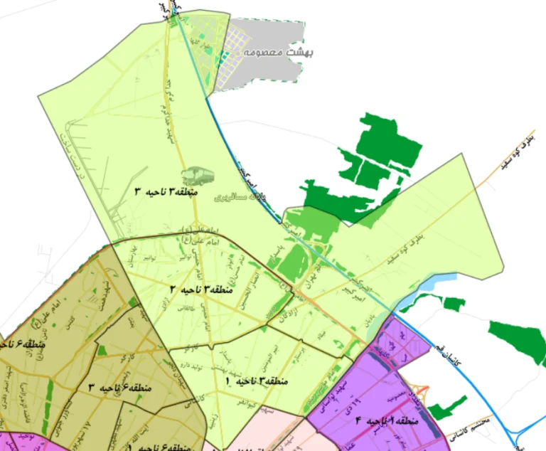
District 3 of Qom
Se Qom region is located in the northernmost part of Qom and has an area of about 20 square kilometers. The neighborhoods of Se Qom region are:
Mahdia town – Tawanir – Imam Hassan Mosque – Baskol – Palestine – Imam Hassan town – Ansar Al Hussain – Baqir Uloom – Medicine production – Refrigerator – Peas – Ismail Abad – Behind the oil warehouse – Shazdeh Bagh – Agha Bakal Sheikh Mehdi Naib Hossein – Gendarmeha – Hanif Nejad – Haj Khalil – Zad – Wadi Salam – Bahdari Lands – Culturists and Municipalities – Azadegan – Lasani – Haj Zainel
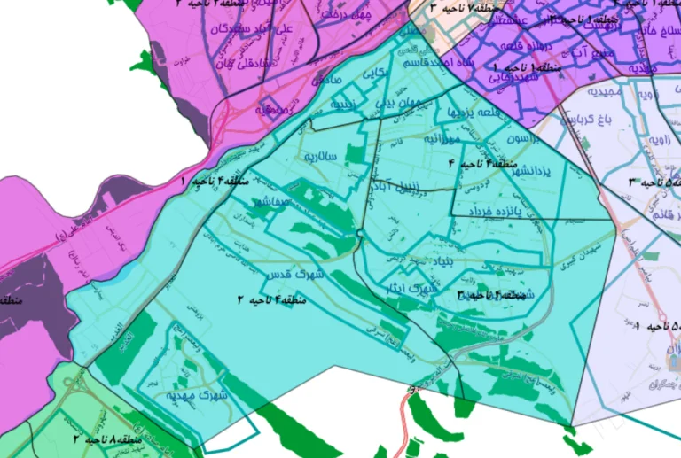
District 4 of Qom
Chahar Qom region is one of the regions of Qom city, which is located in the western and southwestern part of Qom. Most of this area is made up of newly built high-rise luxury towers and has an area of about 27 square kilometers. The neighborhoods of Chahar Qom region are:
Bekai – Mirzaieh – Yazdanshahr – Panzde Khordad – Foundation – Entezne – Zainuddin town – Isar town – Zanbil Abad – Yazdiha castle – Jahanbini – Belvaramin – Sahithi – Zainabieh – Salarieh – Safasher – Quds town – Mahdiyeh town – Mosli

District 5 of Qom
The area of Panj Qom is located at the eastern end of Qom. And it has an area of about 15 square kilometers. The neighborhoods of Panj Qom region are:
Brason – Bagh Karbasi – Majidieh – Zawiya – Taleghani Town – Water Organization Town – Qaim City – Kasegarha – Jamkaran
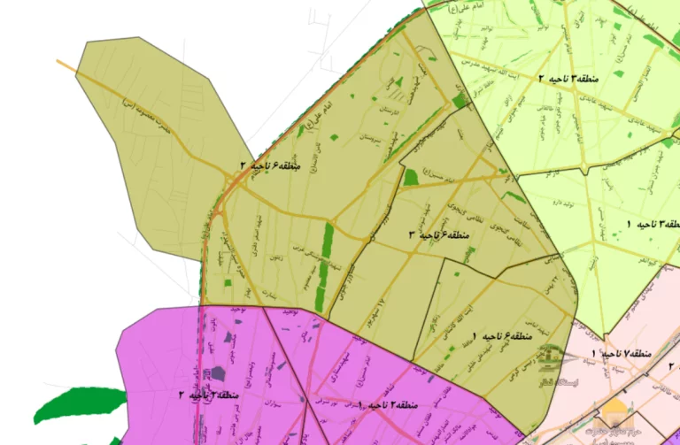
District 6 of Qom
Shesh Qom region is located in the western and northwestern part of Qom. This area has an area of about 12 square kilometers. The neighborhoods of Shesh Qom region are:
Power Plant – Mehrabad – Zandian – Wooden Gate – Zad – Seyyed Masoum – Kamkar Castle – Fatemieh Town – Sayad Shirazi – Imam Hassan Town – Shah Ibrahim – Zandabad
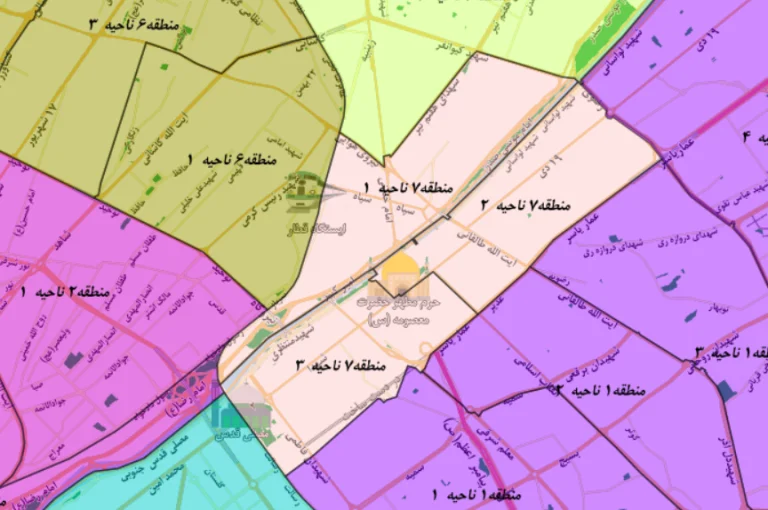
District 7 of Qom
The Haft Qom region is considered the oldest region of Qom and has a special place among the citizens of Qom, and the most important reason for this is the presence of the Holy Shrine of Hazrat Masoumeh (PBUH). This area is located in the most central part of Qom and has an area of about 4 square kilometers.
The neighborhoods of this area are:
Haj Zainel – Khakfarj – Bajak Ik – Cotton Bagh – Alocho – Arabia (Arabistan) – Tekya Agha Seyed Hossein – Eshghali – Maidan Nou – Qom Nou – Eram – Ghazi Glacier – Goz Qala – Safaiyah – Joy Shore – Sadouq – Durshahr
District 8 of Qom
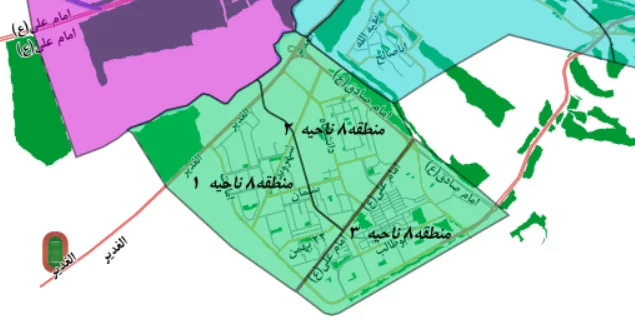
District 8 of Qom is located in the southernmost part of Qom city. Of course, the citizens of Qom city also know this area as Pardisan. The size of this area is about 16.5 square kilometers.
The neighborhoods of this area are:
Seminary and University Town – Pardisan Town – Pardisan City – Neighborhood 1 Mehr Housing – Neighborhood 2 Mehr Housing – Neighborhood 3 Mehr Housing – Neighborhood 4 Mehr Housing – Neighborhood 5 Mehr Housing – Neighborhood 6 Mehr Housing – Neighborhood 7 Mehr Housing – Neighborhood 8 Mehr Housing – Neighborhood 9, Mehr housing
last word
In this comprehensive article, we introduced the 8 regions along with the localities of Qom. We have also provided you with a map of the 8 regions of Qom on the map. We hope this article was useful for you.


